
Faça uma doação
Mapa topográfico Grand Lake
Clique no mapa para exibir a altitude.
Faça uma doação
Grand Lake
Established in 1881, Grand Lake sits at an elevation of 8,369 feet (2,551 m) and derives its name from the lake on whose shores it is situated: Grand Lake, the largest natural body of water in Colorado. The town of Grand Lake was originally an outfitting and supply point for the mining settlements of Lulu City, Teller City, and Gaskill, but today is a tourist destination adjacent to the western entrance to Rocky Mountain National Park, which surrounds the lake and the town on three sides. Grand Lake was the Grand County seat of government from 1882 to 1888. It was incorporated on June 23, 1944.
Faça uma doação
Sobre este mapa
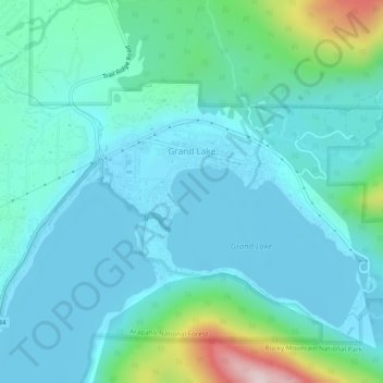
Nome: Mapa topográfico Grand Lake, altitude, relevo.
Local: Grand Lake, Grand County, Colorado, United States (40.23787 -105.84483 40.25877 -105.79689)
Altitude média: 2.630 m
Altitude mínima: 2.552 m
Altitude máxima: 3.013 m
Faça uma doação
Outros mapas topográficos
Clique em um mapa para visualizar sua topografia, sua altitude e seu relevo.
Winter Park
United States > Colorado > Grand County
Its elevation ranges from approximately 8,700 to 12,060 feet (2,650 to 3,680 m) above sea level, and is considered sub-alpine country. It is snow-covered for about six months a year. Although the town center is at about 9,000 feet (2,700 m) above sea level, Winter Park, using administrative boundaries as a…
Altitude média: 3.061 m
Faça uma doação
Faça uma doação