
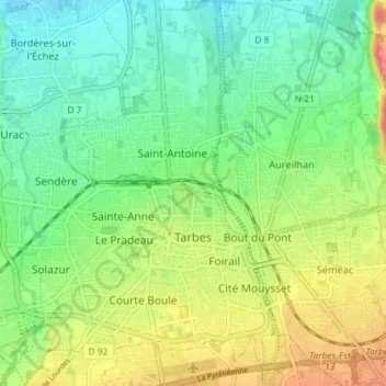
Mapa topográfico Tarbes
Mapa interativo
Clique no mapa para exibir a altitude.
Sobre este mapa
Nome: Mapa topográfico Tarbes, altitude, relevo.
Altitude média: 308 m
Altitude mínima: 283 m
Altitude máxima: 349 m
Tarbes is a Pre-Pyrenees town within the rich agricultural plain of the river Adour, 155 kilometres (96 miles) southwest of Toulouse, 144 kilometres (89 miles) to the east of Bayonne, 70 kilometres (43 miles) southwest of Auch and 20 kilometres (12 miles) northeast of Lourdes. Tarbes is 1 hr 30 mins from the Atlantic Ocean, 2 hrs 50 mins from the Languedoc coast and 35 minutes from the nearest ski resorts. It is located at an average elevation of 304 metres (997 feet).
Outros mapas topográficos
Clique em um mapa para visualizar sua topografia, sua altitude e seu relevo.
Germ
France > Occitania > Hautes Pyrenees
Germ, Bagnères-de-Bigorre, Hautes Pyrenees, Occitania, Metropolitan France, 65240, France
Altitude média: 1.677 m
Les Angles
France > Occitania > Hautes Pyrenees
Les Angles, Argelès-Gazost, Hautes Pyrenees, Occitania, Metropolitan France, 65100, France
Altitude média: 529 m
Grust
France > Occitania > Hautes Pyrenees > Grust
Grust, Argelès-Gazost, Hautes Pyrenees, Occitania, Metropolitan France, 65120, France
Altitude média: 1.149 m