
Obrigado por apoiar este site ❤️
Faça uma doação
Faça uma doação
Mapa topográfico Penida Island
Clique no mapa para exibir a altitude.
Obrigado por apoiar este site ❤️
Faça uma doação
Faça uma doação
Penida Island
Nusa Penida (Balinese: ᬦᬸᬲᬧᭂᬦᬶᬤ, romanized: nusa pĕnida) is an island located near the southeastern Indonesian island of Bali, which forms a district of the same name in Klungkung Regency. The Badung Strait separates the island and Bali. The interior of Nusa Penida is hilly with a maximum altitude of 524 metres, and the climate is drier than Bali. Like Bali, it is a major tourist destination.
Obrigado por apoiar este site ❤️
Faça uma doação
Faça uma doação
Sobre este mapa
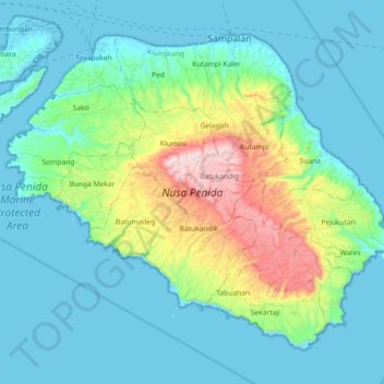
Nome: Mapa topográfico Penida Island, altitude, relevo.
Altitude média: 104 m
Altitude mínima: -4 m
Altitude máxima: 517 m
Obrigado por apoiar este site ❤️
Faça uma doação
Faça uma doação