
Faça uma doação
Mapa topográfico Saskatoon
Clique no mapa para exibir a altitude.
Faça uma doação
Saskatoon
Saskatoon lies on a long belt of rich, potassic chernozem in middle-southern Saskatchewan and is found in the aspen parkland biome. The lack of surrounding mountainous topography gives the city a relatively flat grid, though the city does sprawl over a few hills and into a few valleys. The lowest point in the city is the river, while the highest point is in the Sutherland-College Park area. Saskatoon, on a cross-section from west to east, has a general decline in elevation above sea level heading towards the river, and on the east bank of the river, the terrain is mostly level until outside the city, where it begins to decrease in elevation again.
Faça uma doação
Sobre este mapa
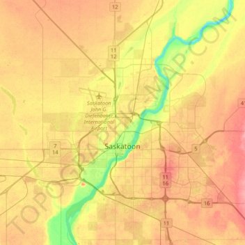
Nome: Mapa topográfico Saskatoon, altitude, relevo.
Local: Saskatoon, Saskatchewan, Canada (52.06980 -106.82497 52.23114 -106.50370)
Altitude média: 504 m
Altitude mínima: 462 m
Altitude máxima: 536 m
Faça uma doação
Outros mapas topográficos
Clique em um mapa para visualizar sua topografia, sua altitude e seu relevo.