
Obrigado por apoiar este site ❤️
Faça uma doação
Faça uma doação
Mapa topográfico Love
Clique no mapa para exibir a altitude.
Obrigado por apoiar este site ❤️
Faça uma doação
Faça uma doação
Sobre este mapa
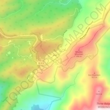
Nome: Mapa topográfico Love, altitude, relevo.
Local: Love, Augusta County, Virginia, 22976, United States (37.86542 -79.03003 37.90542 -78.99003)
Altitude média: 751 m
Altitude mínima: 428 m
Altitude máxima: 1.079 m
Obrigado por apoiar este site ❤️
Faça uma doação
Faça uma doação
Outros mapas topográficos
Clique em um mapa para visualizar sua topografia, sua altitude e seu relevo.
Obrigado por apoiar este site ❤️
Faça uma doação
Faça uma doação
Stuarts Draft
United States > Virginia > Augusta County
Stuarts Draft includes several natural and man-made ponds. Lake Wilda is Green Pond is a naturally occurring high-elevation pond on the Big Levels Ridge. It is five acres in size during the wet season. The Virginia Commission of Game and Inland Fisheries constructed the Maple Flats Ponds in the late 1950s to…
Altitude média: 457 m
Obrigado por apoiar este site ❤️
Faça uma doação
Faça uma doação