
Faça uma doação
Mapa topográfico Trenton
Clique no mapa para exibir a altitude.
Faça uma doação
Sobre este mapa
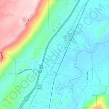
Nome: Mapa topográfico Trenton, altitude, relevo.
Local: Trenton, Dade County, Georgia, United States (34.85374 -85.52850 34.89734 -85.49383)
Altitude média: 280 m
Altitude mínima: 205 m
Altitude máxima: 508 m
Faça uma doação
Outros mapas topográficos
Clique em um mapa para visualizar sua topografia, sua altitude e seu relevo.
Cloudland Canyon State Park
United States > Georgia > Dade County
Cloudland Canyon State Park is a 3,485 acres (14.10 km2) Georgia state park located near Trenton and Cooper Heights on the western edge of Lookout Mountain. One of the largest and most scenic parks in Georgia, it contains rugged geology, and offers visitors a range of vistas across the deep gorge cut through…
Altitude média: 488 m
Faça uma doação