Geolocalizar

Mapa topográfico Mundakai

Clique no mapa para exibir a altitude.

Sobre este mapa

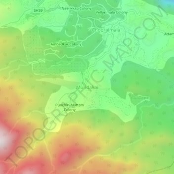
Nome: Mapa topográfico Mundakai, altitude, relevo.

Local: Mundakai, Vythiri, Wayanad, Kerala, India (11.46648 76.13572 11.50648 76.17572)

Altitude média: 1.020 m

Altitude mínima: 568 m

Altitude máxima: 1.652 m

Outros mapas topográficos

Clique em um mapa para visualizar sua topografia, sua altitude e seu relevo.

Palakkad

India > Kerala

Palakkad (Malayalam: [pɐːlɐkːɐːɖɨ̆] (listen)) is one of the 14 districts in the Indian state of Kerala. It was carved out from the southeastern region of the former Malabar District on 1 January 1957. It is located at the centre of Kerala. It is the largest district in the state since 2006. The city…

Altitude média: 305 m

Kuttanad

India > Kerala

Altitude média: 3 m

Balussery

India > Kerala > Koyilandi > Balusseri

Altitude média: 39 m

Rajamalai

India > Kerala > Devikulam > Lakkomukudi

Altitude média: 1.885 m

Water Bodies

India > Kerala

Altitude média: 5 m

Oloppara

India > Kerala > Kozhikode > Chelannur > Chirattatu colony

Altitude média: 20 m

Idukki

India > Kerala

Altitude média: 751 m

Unnikulam

India > Kerala > Koyilandi > Ekarool > Kalluvettum Kandy

Altitude média: 49 m

Elamkunnapuzha

India > Kerala > Kochi > Elamkunnapuzha

Altitude média: 2 m

Tholur

India > Kerala > Thrissur > Parappur

Altitude média: 6 m

Iritty

India > Kerala

Altitude média: 345 m

Peringavu

India > Kerala > Kondotty > Kakkov

Altitude média: 39 m

Peringavu

India > Kerala > Thrissur > Viyyur

Altitude média: 10 m

Kottayam

India > Kerala

Altitude média: 124 m

Mananthavady

India > Kerala

Altitude média: 734 m

Vythiri

India > Kerala

Altitude média: 746 m

South Cliff

India > Kerala > Varkala > Varkala

Altitude média: 17 m

Mamangalam

India > Kerala > Kanayannur > Ernakulam

Altitude média: 8 m

Payyambalam Beach

India > Kerala > Kannur

Altitude média: 6 m

Madakkathara

India > Kerala > Thrissur > Thanikkudam

Altitude média: 56 m

Sarovaram Bio Park

India > Kerala > Kozhikode > Erenjippalam

Altitude média: 14 m

Mananchira

India > Kerala > Kozhikode > Kozhikode

Altitude média: 12 m

Chengannur

India > Kerala

Altitude média: 13 m

Alapuzha

India > Kerala > Kottayam > Kottayam

Altitude média: 10 m

Ranni

India > Kerala > Ranni

Ranni is located at 9°23′N 76°49′E / 9.38°N 76.81°E / 9.38; 76.81. It has an average elevation of 131 m (433 ft) above sea level. The location and elevation is measured around the township. However, towards the east, the elevation is much higher. River Pamba flows through Ranni. The township…

Altitude média: 93 m

Alappuzha

India > Kerala

The Vembanad lake, which lies below the sea level, is the longest lake in the Indian peninsula, and the district of Alappuzha lies between this lake and the Arabian Sea. Kuttanad region of the Alappuzha district, which lies below the sea level, is the point of least elevation in the entire India. Kuttanad,…

Altitude média: 21 m

Vypin

India > Kerala > Kochi > Edavanakkad

Altitude média: 3 m

Payyannur Taluk

India > Kerala > Payyannur Taluk

Altitude média: 62 m

Kalliasseri Block

India > Kerala > Payyannur Taluk

Altitude média: 14 m

Kuriannoor

India > Kerala > Thiruvalla > Maramon

Altitude média: 63 m

Peralassery

India > Kerala > Kadachira

Altitude média: 21 m

Kanayannur

India > Kerala > Kanayannur

Altitude média: 10 m

Meenangadi

India > Kerala > Sulthanbathery > Meenangadi

Altitude média: 785 m

Pazhayannur

India > Kerala > Talappilly > Pazhayanur

Altitude média: 80 m

Perumpetty

India > Kerala > Mallappally

Altitude média: 89 m

Kundara

India > Kerala > Kollam > Kundara

Altitude média: 32 m

Vadakara

India > Kerala > Vadakara

Altitude média: 186 m

Pathanamthitta

India > Kerala

The district can be divided into three natural geographical regions: the highland, the midland and the lowland. The highland stretches through the Western Ghats, where the hills are tall and covered with thick forests. Western Ghats maintains an average altitude of around 800 m. It descends to the smaller…

Altitude média: 390 m

Karthikappally

India > Kerala > Karthikappally

Altitude média: 4 m

Chathari

India > Kerala > Kanayannur > Thrippunithura > Chathari

Altitude média: 8 m

Kuthiravattom

India > Kerala > Kozhikode > Kozhikode > Pottammal

Altitude média: 17 m

Kozhencherry

India > Kerala > Kozhencherry

Altitude média: 37 m

Puthentheru

India > Kerala > Tirur > Puthentheru

Altitude média: 11 m

Kolazhy

India > Kerala > Thrissur > Mulakunnathukavu

Altitude média: 12 m