
Obrigado por apoiar este site ❤️
Faça uma doação
Faça uma doação
Mapa topográfico Isla de Culebra
Clique no mapa para exibir a altitude.
Obrigado por apoiar este site ❤️
Faça uma doação
Faça uma doação
Isla de Culebra
Culebra is characterized by an irregular topography resulting in a long intricate shoreline. The island is approximately 7 by 5 miles (11 by 8 km). The coast is marked by cliffs, sandy coral beaches and mangrove forests. Inland, the tallest point on the island is Mount Resaca, with an elevation of 636 feet (193.9 meters), followed by Balcón Hill, with an elevation of 545 feet (166.1 meters).
Obrigado por apoiar este site ❤️
Faça uma doação
Faça uma doação
Sobre este mapa
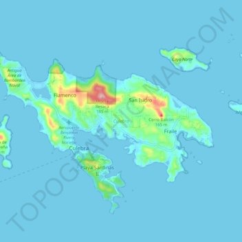
Nome: Mapa topográfico Isla de Culebra, altitude, relevo.
Altitude média: 11 m
Altitude mínima: -3 m
Altitude máxima: 188 m
Obrigado por apoiar este site ❤️
Faça uma doação
Faça uma doação