
Faça uma doação
Mapa topográfico Bryce
Clique no mapa para exibir a altitude.
Faça uma doação
Sobre este mapa
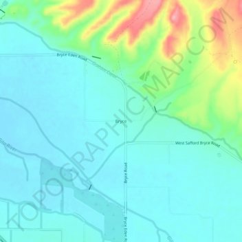
Nome: Mapa topográfico Bryce, altitude, relevo.
Local: Bryce, Graham County, Arizona, 85543, United States (32.90895 -109.84786 32.94895 -109.80786)
Altitude média: 876 m
Altitude mínima: 848 m
Altitude máxima: 972 m
Faça uma doação
Outros mapas topográficos
Clique em um mapa para visualizar sua topografia, sua altitude e seu relevo.
Safford
United States > Arizona > Graham County
The climate is cold semi-arid (Köppen: BSk) softened by the plateau rise (it receives enough rainfall not to fall into a cold desert, BWk). It is much hotter than most places in eastern Arizona due to its relatively low elevation of 2,953 feet (900 m) at the Agricultural Center where records are kept, and…
Altitude média: 912 m
Safford
United States > Arizona > Graham County
The climate is hot semi-arid (Köppen: BSh) softened by the plateau rise (it receives enough rainfall not to fall into a hot desert, BWh). It is much hotter than most places in eastern Arizona due to its relatively low elevation of 2,953 feet (900 m) at the Agricultural Center where records are kept, and often…
Altitude média: 911 m