
Faça uma doação
Mapa topográfico Sydney
Clique no mapa para exibir a altitude.
Faça uma doação
Sobre este mapa
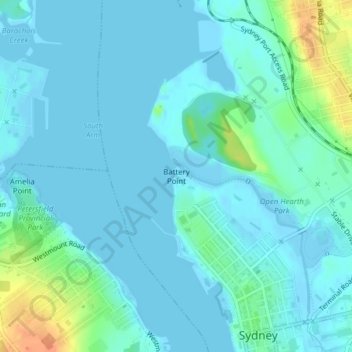
Nome: Mapa topográfico Sydney, altitude, relevo.
Altitude média: 7 m
Altitude mínima: -8 m
Altitude máxima: 38 m
Faça uma doação
Outros mapas topográficos
Clique em um mapa para visualizar sua topografia, sua altitude e seu relevo.
Faça uma doação
Faça uma doação
Sydney
Canada > Nova Scotia > Cape Breton Regional Municipality
Sydney is on the east bank of the Sydney River where it discharges into South Arm of Sydney Harbour. Elevation ranges from sea level to 66 m (217 ft) above sea level.
Altitude média: 30 m
Faça uma doação
Faça uma doação
Faça uma doação
Faça uma doação
Boularderie Island
Canada > Nova Scotia > Cape Breton Regional Municipality > Southside Boularderie
Altitude média: 75 m
Faça uma doação
Brown Islands
Canada > Nova Scotia > Cape Breton Regional Municipality > Main-à-Dieu
Altitude média: 0 m
Faça uma doação
Faça uma doação
Faça uma doação
Faça uma doação
Sydney
Canada > Nova Scotia > Cape Breton Regional Municipality
Sydney is on the east bank of the Sydney River where it discharges into South Arm of Sydney Harbour. Elevation ranges from sea level to 66 m (217 ft) above sea level.
Altitude média: 30 m
Faça uma doação
Sydney
Canada > Nova Scotia > Cape Breton Regional Municipality
Sydney is on the east bank of the Sydney River where it discharges into South Arm of Sydney Harbour. Elevation ranges from sea level to 66 m (217 ft) above sea level.
Altitude média: 30 m