
Faça uma doação
Mapa topográfico Biljurashi
Clique no mapa para exibir a altitude.
Faça uma doação
Biljurashi
Baljurashi (Arabic: بَـلْـجُـرَشِي) or Biljurashi (Arabic: بِـلْـجُـرَشِي) is a city in Al Bahah Region, south-western Saudi Arabia. It is located at around 19°51′40″N 41°33′40″E / 19.8612090°N 41.5609769°E / 19.8612090; 41.5609769 in the elevation of cca 2,000 metres (6,600 feet). It was the capital of the region which includes the tribes of Ghamid and Zahran. It is a medium-sized city in Al Bahah Region. The temperature usually varies between 2 °C (36 °F) in winter and 30 °C (86 °F) in summer. The best time for a visit is from mid-August till the end of September. Most of the native people of Baljurashi live outside it; however, a great number of them spend their summer vacations in the city, which explains the massive increase in population number during summer.
Faça uma doação
Sobre este mapa
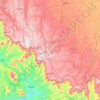
Nome: Mapa topográfico Biljurashi, altitude, relevo.
Local: Biljurashi, Al-Bahah Province, Saudi Arabia (19.69809 41.50283 20.29958 41.97897)
Altitude média: 1.528 m
Altitude mínima: 268 m
Altitude máxima: 2.563 m
Faça uma doação
Outros mapas topográficos
Clique em um mapa para visualizar sua topografia, sua altitude e seu relevo.