
Obrigado por apoiar este site ❤️
Faça uma doação
Faça uma doação
Mapa topográfico Estepona
Clique no mapa para exibir a altitude.
Obrigado por apoiar este site ❤️
Faça uma doação
Faça uma doação
Estepona
Estepona (Spanish pronunciation: [esteˈpona]) is a town and municipality in the comarca of the Costa del Sol, southern Spain. It is located in the province of Málaga, part of the autonomous community of Andalusia. Its district covers an area of 137 square kilometers in a fertile valley crossed by small streams and a mountainous areas dominated by the Sierra Bermeja, which reaches an elevation of 1,449 m at the peak of Los Reales.
Obrigado por apoiar este site ❤️
Faça uma doação
Faça uma doação
Sobre este mapa
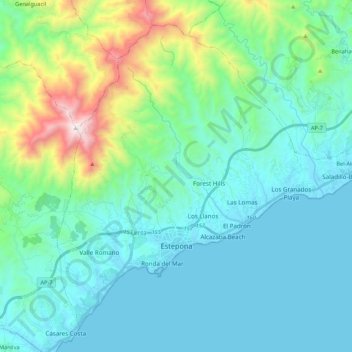
Nome: Mapa topográfico Estepona, altitude, relevo.
Local: Estepona, Costa del Sol Occidental, Malaga, Andalusia, Spain (36.38613 -5.21967 36.53578 -5.00492)
Altitude média: 265 m
Altitude mínima: -1 m
Altitude máxima: 1.439 m
Obrigado por apoiar este site ❤️
Faça uma doação
Faça uma doação