
Mapa topográfico Kalimpong
Mapa interativo
Clique no mapa para exibir a altitude.
Kalimpong
Kalimpong is a city and a municipality in the Indian state of West Bengal. It is located at an average elevation of 1,250 metres (4,101 ft). The city is the headquarters of the Kalimpong district. Kalimpong district region comes under Gorkhaland Territorial Administration which is an autonomous governing body within the state of West Bengal. The Indian Army's 27 Mountain Division is located on the outskirts of the city.
Sobre este mapa
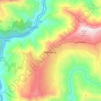
Nome: Mapa topográfico Kalimpong, altitude, relevo.
Local: Kalimpong, Kalimpong -I, Kalimpong, West Bengal, 734301, India (27.03169 88.43290 27.11169 88.51290)
Altitude média: 838 m
Altitude mínima: 196 m
Altitude máxima: 1.683 m