
Mapa topográfico Wiesbaden
Clique no mapa para exibir a altitude.
Wiesbaden
The highest point of the Wiesbaden municipality is located northwest of the city center near the summit of the Hohe Wurzel, with an elevation of 608 metres (1,995 ft) above sea level. The lowest point is the harbour entrance of Schierstein at 83 metres (272 ft) above sea level. The central square (the Schlossplatz, or palace square) is at an elevation of 115 metres (377 ft).
Sobre este mapa
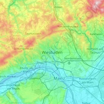
Nome: Mapa topográfico Wiesbaden, altitude, relevo.
Local: Wiesbaden, Hesse, 15183, Germany (49.92204 8.08166 50.24204 8.40166)
Altitude média: 258 m
Altitude mínima: 79 m
Altitude máxima: 880 m