
Mapa topográfico Glattalpsee
Mapa interativo
Clique no mapa para exibir a altitude.
Sobre este mapa
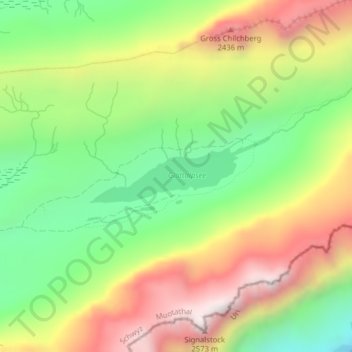
Nome: Mapa topográfico Glattalpsee, altitude, relevo.
Local: Glattalpsee, Muotathal, Schwyz, 6436, Schweiz (46.91758 8.89636 46.92119 8.90955)
Altitude média: 2.063 m
Altitude mínima: 1.636 m
Altitude máxima: 2.577 m
Der Glattalpsee hat eine Fläche von 27,6 Hektar und befindet sich auf einer Höhe von 1853 m ü. M. Obwohl noch auf dem östlichen Schwyzer Kantonsgebiet liegend, gehört die Region bereits zu den Glarner Alpen. Gespiesen wird der See durch den Glattalpseebach, den Hinter Läckibach und den Vorderer Läckibach.