
Mapa topográfico Schneckengrün
Mapa interativo
Clique no mapa para exibir a altitude.
Sobre este mapa
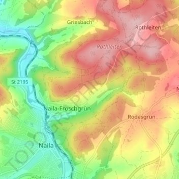
Nome: Mapa topográfico Schneckengrün, altitude, relevo.
Altitude média: 574 m
Altitude mínima: 485 m
Altitude máxima: 660 m
Outros mapas topográficos
Clique em um mapa para visualizar sua topografia, sua altitude e seu relevo.
Döbrastöcken
Deutschland > Bayern > Landkreis Hof > Naila
Döbrastöcken, Naila, Landkreis Hof, Bayern, 95131, Deutschland
Altitude média: 646 m
Lippertsgrün
Deutschland > Bayern > Landkreis Hof > Naila > Lippertsgrün
Lippertsgrün, Naila, Landkreis Hof, Bayern, 95119, Deutschland
Altitude média: 633 m
Linden
Deutschland > Bayern > Landkreis Hof > Naila > Linden
Linden, Naila, Landkreis Hof, Bayern, 95119, Deutschland
Altitude média: 557 m
Marlesreuth
Deutschland > Bayern > Landkreis Hof > Naila
Marlesreuth, Naila, Landkreis Hof, Bayern, 95119, Deutschland
Altitude média: 595 m