
Faça uma doação
Mapa topográfico Potsdam
Clique no mapa para exibir a altitude.
Faça uma doação
Potsdam
The traditional towns in the governorate were small, however, in the course of the industrial labour migration some reached the rank of urban districts. The principal towns were Brandenburg upon Havel, Köpenick, Potsdam, Prenzlau, Spandau and Ruppin. Until 1875 Berlin also was a town within the governorate. After its disentanglement a number of its suburbs outside Berlin's municipal borders grew to towns, many forming urban Bezirke within the governorate of Potsdam such as Charlottenburg, Lichtenberg, Rixdorf (after 1912 Neukölln), and Schöneberg (all of which, as well as Köpenick and Spandau, incorporated into Greater Berlin in 1920). The urban Bezirke were (years indicating the elevation to rank of urban Bezirkor affiliation with Potsdam governorate, respectively).
Faça uma doação
Sobre este mapa
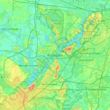
Nome: Mapa topográfico Potsdam, altitude, relevo.
Local: Potsdam, Brandenburg, 14467, Germany (52.24093 12.89914 52.56093 13.21914)
Altitude média: 43 m
Altitude mínima: 25 m
Altitude máxima: 121 m
Faça uma doação
Outros mapas topográficos
Clique em um mapa para visualizar sua topografia, sua altitude e seu relevo.