
Mapa topográfico Tijuana
Mapa interativo
Clique no mapa para exibir a altitude.
Sobre este mapa
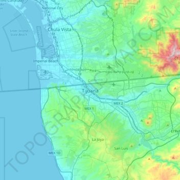
Nome: Mapa topográfico Tijuana, altitude, relevo.
Altitude média: 141 m
Altitude mínima: -2 m
Altitude máxima: 1.074 m
Housing development in the Tijuana Hills has led to eradication of many seasonal mountain streams. This lack of natural drainage makes places within the city vulnerable to landslides during the rainy season. The varied terrain of Tijuana gives the city elevation extremes that range from sea level to 790 meters (2,590 ft). As downtown Tijuana was built at the bottom of the river valley, the district is subject to seasonal flooding created by drain-off from the Tijuana Hills. During this time, east-bound portions of the Via Rapida (east–west highway) may be blocked off by the Tijuana Police due to hazardous conditions.
Outros mapas topográficos
Clique em um mapa para visualizar sua topografia, sua altitude e seu relevo.
Lomas del Valle
Mexico > Baja California > Municipio de Tijuana > Lomas del Valle
Lomas del Valle, Municipio de Tijuana, Baja California, 22254, Mexico
Altitude média: 220 m
Hacienda Casa Grande
Mexico > Baja California > Municipio de Tijuana > Hacienda Casa Grande
Hacienda Casa Grande, Municipio de Tijuana, Baja California, 22244, Mexico
Altitude média: 170 m
Municipio de Tijuana
Mexico > Baja California > Municipio de Tijuana
Municipio de Tijuana, Baja California, Mexico
Altitude média: 369 m