
Obrigado por apoiar este site ❤️
Faça uma doação
Faça uma doação
Mapa topográfico Cobham
Clique no mapa para exibir a altitude.
Obrigado por apoiar este site ❤️
Faça uma doação
Faça uma doação
Cobham
The River Mole runs through Cobham, with a visitor area and well-surfaced path by the mill in the High Street, dividing the low-rise urban village/town centre from the remaining agricultural parts of Cobham in the west and south. This can flood small, old parts of the village centre in extreme rainfall. Elevation reaches a minimum here of 20 metres (66 ft) above sea level.
Obrigado por apoiar este site ❤️
Faça uma doação
Faça uma doação
Sobre este mapa
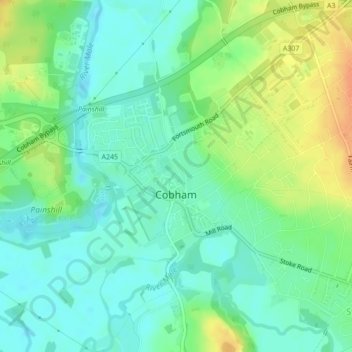
Nome: Mapa topográfico Cobham, altitude, relevo.
Local: Cobham, Surrey, South East England, England, United Kingdom (51.32439 -0.42790 51.33843 -0.39933)
Altitude média: 28 m
Altitude mínima: 14 m
Altitude máxima: 51 m
Obrigado por apoiar este site ❤️
Faça uma doação
Faça uma doação