
Obrigado por apoiar este site ❤️
Faça uma doação
Faça uma doação
Mapa topográfico Lardos
Clique no mapa para exibir a altitude.
Obrigado por apoiar este site ❤️
Faça uma doação
Faça uma doação
Sobre este mapa
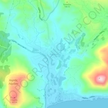
Nome: Mapa topográfico Lardos, altitude, relevo.
Altitude média: 91 m
Altitude mínima: 0 m
Altitude máxima: 378 m
Obrigado por apoiar este site ❤️
Faça uma doação
Faça uma doação
Outros mapas topográficos
Clique em um mapa para visualizar sua topografia, sua altitude e seu relevo.
Megisti
Greece > Aegean > Rhodes Regional Unit > Municipality of Meyisti
West of the town, beyond the summit of the island known as Vigla (270 m), stands Palaiokastro (old castle), the island's ancient acropolis. This fortified elevation has classical origins (see below, history section): its plan is rectangular and measures 60 by 80 metres (200 ft × 260 ft). In its interior stand…
Altitude média: 40 m
Obrigado por apoiar este site ❤️
Faça uma doação
Faça uma doação