
Mapa topográfico London Colney
Clique no mapa para exibir a altitude.
Sobre este mapa
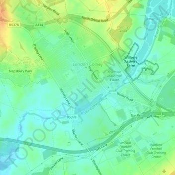
Nome: Mapa topográfico London Colney, altitude, relevo.
Altitude média: 75 m
Altitude mínima: 63 m
Altitude máxima: 95 m
Outros mapas topográficos
Clique em um mapa para visualizar sua topografia, sua altitude e seu relevo.
St Albans
United Kingdom > England > Hertfordshire > St Albans
St Albans was an ancient borough created following the dissolution of the monastery in 1539. It consisted of the ancient parish of St Albans (also known as the Abbey parish) and parts of St Michael and St Peter. The municipal corporation was reformed by the Municipal Corporations Act 1835 and the boundary was…
Altitude média: 100 m
Highfield Park
United Kingdom > England > Hertfordshire > St Albans > Colney Heath
Altitude média: 87 m
Blackmore End
United Kingdom > England > Hertfordshire > St Albans > Wheathampstead
Altitude média: 114 m
Lower Gustard Wood
United Kingdom > England > Hertfordshire > St Albans > Wheathampstead
Altitude média: 112 m
Napsbury Park
United Kingdom > England > Hertfordshire > St Albans > London Colney
Altitude média: 78 m