
Faça uma doação
Mapa topográfico Botley Hill
Clique no mapa para exibir a altitude.
Faça uma doação
Botley Hill
Botley Hill is a Marilyn (a hill with topographic prominence of at least 150m), and the third highest point in the county (after the peaks of Leith Hill south of Dorking and Gibbet Hill in Hindhead, both on the Greensand Ridge).
Faça uma doação
Sobre este mapa
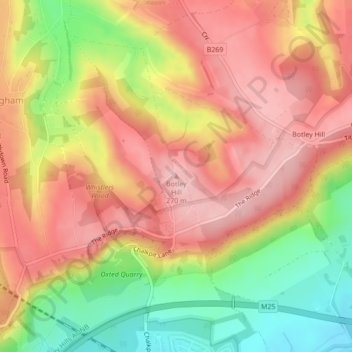
Nome: Mapa topográfico Botley Hill, altitude, relevo.
Altitude média: 206 m
Altitude mínima: 109 m
Altitude máxima: 271 m
Faça uma doação
Outros mapas topográficos
Clique em um mapa para visualizar sua topografia, sua altitude e seu relevo.
Warlingham
United Kingdom > England > Surrey > Tandridge
Elevations vary from 110m AOD at Woldingham Road, at the southernmost point of the parish, with a gentle increase in height through the village along the main road heading to the southeast, to the highest elevation (199.6m) at Limpsfield Road.
Altitude média: 163 m
Faça uma doação
Faça uma doação
Warlingham
United Kingdom > England > Surrey > Tandridge
Elevations vary from 110m AOD at Woldingham Road, at the southernmost point of the parish, with a gentle increase in height through the village along the main road heading to the southeast, to the highest elevation (199.6m) at Limpsfield Road.
Altitude média: 163 m