
Mapa topográfico Taman Seruni Indah
Mapa interativo
Clique no mapa para exibir a altitude.
Sobre este mapa
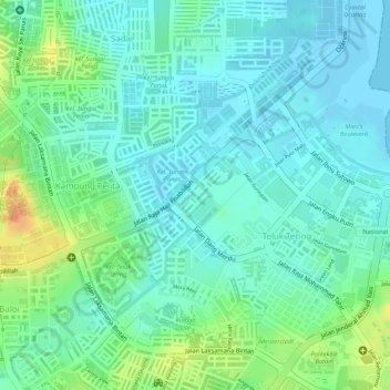
Nome: Mapa topográfico Taman Seruni Indah, altitude, relevo.
Local: Taman Seruni Indah, Batam City, Riau Islands, 29456, Indonesia (1.11992 104.02978 1.13992 104.04978)
Altitude média: 16 m
Altitude mínima: -2 m
Altitude máxima: 52 m
Outros mapas topográficos
Clique em um mapa para visualizar sua topografia, sua altitude e seu relevo.
Lubuk Baja Kota
Indonesia > Riau Islands > Batam City
Lubuk Baja Kota, Batam City, Riau Islands, Sumatra, 29443, Indonesia
Altitude média: 18 m
Teluk Tering
Indonesia > Riau Islands > Batam City > Teluk Tering
Teluk Tering, Batam City, Riau Islands, 24961, Indonesia
Altitude média: 13 m
Keban
Indonesia > Riau Islands > Batam City
Keban, Batam City, Riau Islands, Indonesia
Altitude média: 4 m