
Obrigado por apoiar este site ❤️
Faça uma doação
Faça uma doação
Mapa topográfico Wiyâshâkimî Lake
Clique no mapa para exibir a altitude.
Obrigado por apoiar este site ❤️
Faça uma doação
Faça uma doação
Sobre este mapa
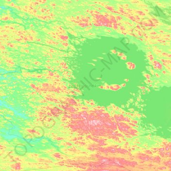
Nome: Mapa topográfico Wiyâshâkimî Lake, altitude, relevo.
Local: Wiyâshâkimî Lake, Kativik, Northern Quebec, Quebec, Canada (55.93348 -75.11712 56.36354 -73.90449)
Altitude média: 269 m
Altitude mínima: 210 m
Altitude máxima: 416 m
Obrigado por apoiar este site ❤️
Faça uma doação
Faça uma doação
Outros mapas topográficos
Clique em um mapa para visualizar sua topografia, sua altitude e seu relevo.
Richmond Gulf
Canada > Quebec > Kativik > Baie-d'Hudson
The topography of Lake Tasuijaq is the consequence of two geological faults running parallel to the coast. The resulting dislocation has given rise to the cliffs that dominate the western shore of the lake.
Altitude média: 0 m
Obrigado por apoiar este site ❤️
Faça uma doação
Faça uma doação