
Obrigado por apoiar este site ❤️
Faça uma doação
Faça uma doação
Mapa topográfico Valencia
Clique no mapa para exibir a altitude.
Obrigado por apoiar este site ❤️
Faça uma doação
Faça uma doação
Valencia
Valencia occupies an area of 14,749 hectares (36,450 acres), 35% of which are classified as plains. The town is 65% mountainous, with elevation averaging from 200 to 500 metres (660 to 1,640 ft) above sea level, with the top of Mount Talinis at an elevation of 1,903 metres (6,243 ft) along the municipal southern boundary. The climate in the municipality is relatively cool, especially at higher elevations.
Obrigado por apoiar este site ❤️
Faça uma doação
Faça uma doação
Sobre este mapa
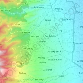
Nome: Mapa topográfico Valencia, altitude, relevo.
Local: Valencia, Negros Oriental, Central Visayas, 6215, Philippines (9.24178 123.20468 9.32178 123.28468)
Altitude média: 250 m
Altitude mínima: 24 m
Altitude máxima: 966 m
Obrigado por apoiar este site ❤️
Faça uma doação
Faça uma doação
Outros mapas topográficos
Clique em um mapa para visualizar sua topografia, sua altitude e seu relevo.