
Mapa topográfico Chenango County
Mapa interativo
Clique no mapa para exibir a altitude.
Sobre este mapa
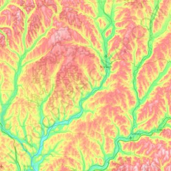
Nome: Mapa topográfico Chenango County, altitude, relevo.
Local: Chenango County, New York, USA (42.19497 -75.88983 42.74542 -75.29294)
Altitude média: 442 m
Altitude mínima: 264 m
Altitude máxima: 656 m
Outros mapas topográficos
Clique em um mapa para visualizar sua topografia, sua altitude e seu relevo.
Niagara Falls
USA > New York > Niagara Falls
Niagara Falls, Niagara County, New York, USA
Altitude média: 180 m
Avalanche Lake
Avalanche Lake, Avalanche Pass Trail, Essex County, New York, USA
Altitude média: 1.066 m
Flat Top Mountain
Flat Top Mountain, Franklin County, New York, USA
Altitude média: 568 m
Mount Warren
Mount Warren, Town of Bovina, Delaware County, New York, USA
Altitude média: 677 m
Buchanan
USA > New York > Buchanan > Town of Cortlandt
Buchanan, Town of Cortlandt, Westchester County, New York, 10511, USA
Altitude média: 27 m
Falls Creek
Falls Creek, Town of Delhi, Delaware County, New York, 13753, USA
Altitude média: 515 m
Sawtooth Mountains
Sawtooth Mountains, Franklin County, New York, USA
Altitude média: 927 m
Farmingville
USA > New York > Farmingville
Farmingville, Suffolk County, New York, 11738, USA
Altitude média: 47 m
North Western
USA > New York > North Western
North Western, Town of Western, Oneida County, New York, 13486, USA
Altitude média: 250 m
Livingston Island
Livingston Island, Town of Philipstown, Putnam County, New York, 10922, USA
Altitude média: 156 m