
Mapa topográfico Kapiti Island
Mapa interativo
Clique no mapa para exibir a altitude.
Sobre este mapa
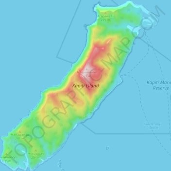
Nome: Mapa topográfico Kapiti Island, altitude, relevo.
Altitude média: 55 m
Altitude mínima: 0 m
Altitude máxima: 498 m
The full original name for the island, Ko te Waewae-Kapiti-o-Tara-rāua-ko-Rangitāne, meaning "the boundary of Tara and Rangitāne", refers to it as a place where the rohe (territories) of Ngāi Tara (now known as Muaūpoko) and Rangitāne iwi adjoined each other. The word kapiti (to be joined) is spelt without a macron, and is unrelated to the word kāpiti (cabbage). The island does not have an official name, but is recorded on topographical maps and hence in the New Zealand Gazetteer as Kapiti Island. In 2010 the Māori Language Commission acknowledged that, while the ordinary word kapiti does not have a macron, iwi of the Kāpiti region have evidence from history and local pronunciation that the place name is a variant form of āpiti, and that Kāpiti (with a macron) is correct.
Outros mapas topográficos
Clique em um mapa para visualizar sua topografia, sua altitude e seu relevo.
Waikanae
New Zealand > Wellington > Kapiti Coast District
Waikanae, Kāpiti Coast District, Wellington, 5036, New Zealand
Altitude média: 112 m