
Mapa topográfico Bochum
Mapa interativo
Clique no mapa para exibir a altitude.
Bochum
The city lies on the low rolling hills of Bochum land ridge (Bochumer Landrücken), part of the Ruhrhöhen (highest elevations) between the Ruhr and Emscher rivers at the border of the southern and northern Ruhr coal region. The highest point of the city is at Kemnader Straße (Kemnader Street) in Stiepel at 196 metres (643 ft) above sea level; the lowest point is 43 metres (141 ft) at the Blumenkamp in Hordel.
Sobre este mapa
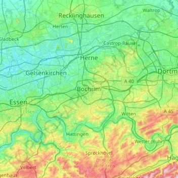
Nome: Mapa topográfico Bochum, altitude, relevo.
Local: Bochum, North Rhine-Westphalia, 44787, Germany (51.32181 7.05966 51.64181 7.37966)
Altitude média: 107 m
Altitude mínima: 28 m
Altitude máxima: 374 m
Outros mapas topográficos
Clique em um mapa para visualizar sua topografia, sua altitude e seu relevo.