
Faça uma doação
Mapa topográfico Getafe
Clique no mapa para exibir a altitude.
Faça uma doação
Getafe
Getafe is located in the southern zone of the autonomous community of Madrid, Spain, in southwestern Europe. It is physically located in the centre of the Iberian Peninsula, north of the Southern Submeseta (part of the Meseta Central), in the Manzanares River basin. Its elevation is 610 – 640 meters above sea level (2000–2100 feet). Its coordinates are 40° 18' N 3° 43' W. The municipal district is 78.74 km2, with a perimeter of 46.5 km. The easternmost part of the municipal district is located within the Parque Regional del Sureste, a protected forest region.
Faça uma doação
Sobre este mapa
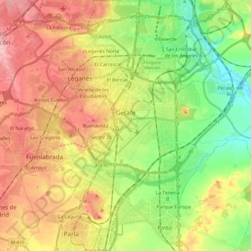
Nome: Mapa topográfico Getafe, altitude, relevo.
Local: Getafe, Community of Madrid, Spain (40.26636 -3.76174 40.33470 -3.57006)
Altitude média: 632 m
Altitude mínima: 550 m
Altitude máxima: 726 m
Faça uma doação
Outros mapas topográficos
Clique em um mapa para visualizar sua topografia, sua altitude e seu relevo.
Faça uma doação
Alcorcón
Spain > Community of Madrid > Área metropolitana de Madrid y Corredor del Henares > Alcorcón
Altitude média: 646 m
La Castellana y El Pilar
Spain > Community of Madrid > Sierra Oeste > Cadalso de los Vidrios
Altitude média: 788 m