
Mapa topográfico Todt Hill
Mapa interativo
Clique no mapa para exibir a altitude.
Sobre este mapa
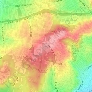
Nome: Mapa topográfico Todt Hill, altitude, relevo.
Altitude média: 75 m
Altitude mínima: 5 m
Altitude máxima: 122 m
Outros mapas topográficos
Clique em um mapa para visualizar sua topografia, sua altitude e seu relevo.
Liberty Island
United States of America > New York > New York
Liberty Island, Manhattan Community Board 1, Manhattan, New York County, New York, Stone Street Historic District, New York, United States of America
Altitude média: 0 m
Wards Island
United States of America > New York > New York
Wards Island, Manhattan Community Board 11, Manhattan, New York County, New York, 11102, United States of America
Altitude média: 35 m
Manhattan
United States of America > New York > New York
Chinatown, Manhattan Community Board 2, Manhattan, New York County, New York, United States of America
Altitude média: 12 m