
Faça uma doação
Mapa topográfico Bellefontaine
Clique no mapa para exibir a altitude.
Faça uma doação
Bellefontaine
The city of Bellefontaine is at the convergence of the humid subtropical (Köppen Cfa) and humid continental (Köppen Dfa) climate zones according to the Köppen climate map. The region is characterized by four distinct seasons. Winters are cool to cold with mild periods, and summers are generally hot and muggy, with significant precipitation year-round. The city is too far south to experience lake effect snow from the Great Lakes region, however it does experience more snow than surrounding areas due to the city's elevation. Traditionally, Bellefontaine's elevation excludes it from tornadoes and floods that affect the majority of the Miami Valley.
Faça uma doação
Sobre este mapa
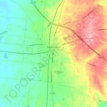
Nome: Mapa topográfico Bellefontaine, altitude, relevo.
Altitude média: 384 m
Altitude mínima: 326 m
Altitude máxima: 471 m
Faça uma doação
Outros mapas topográficos
Clique em um mapa para visualizar sua topografia, sua altitude e seu relevo.