
Mapa topográfico Gran Paradiso
Mapa interativo
Clique no mapa para exibir a altitude.
Gran Paradiso
The peak is the 7th highest mountain in the Graian Alps, with an elevation of 4,061 m. In the SOIUSA (International Standardized Mountain Subdivision of the Alps) the mountain belongs to an alpine subsection called "North-Eastern Graian Alps" (It:Alpi del Gran Paradiso; Fr:Alpes du Grand-Paradis) and also gives its name to the gruppo del Gran Paradiso.
Sobre este mapa
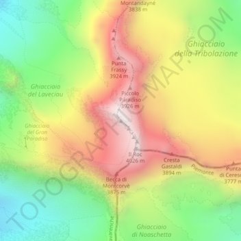
Nome: Mapa topográfico Gran Paradiso, altitude, relevo.
Local: Gran Paradiso, Valsavarenche, Aosta Valley, Italy (45.51777 7.26715 45.51787 7.26725)
Altitude média: 3.459 m
Altitude mínima: 2.950 m
Altitude máxima: 4.019 m