
Mapa topográfico Riedholz
Mapa interativo
Clique no mapa para exibir a altitude.
Sobre este mapa
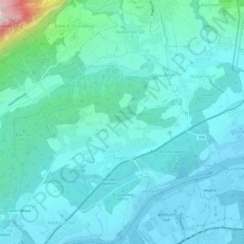
Nome: Mapa topográfico Riedholz, altitude, relevo.
Altitude média: 532 m
Altitude mínima: 418 m
Altitude máxima: 1.253 m
Outros mapas topográficos
Clique em um mapa para visualizar sua topografia, sua altitude e seu relevo.
Günsberg
Schweiz > Solothurn > Amtei Solothurn-Lebern
Günsberg, Bezirk Lebern, Amtei Solothurn-Lebern, Solothurn, 4524, Schweiz
Altitude média: 785 m
Bellach
Schweiz > Solothurn > Amtei Solothurn-Lebern
Bellach, Bezirk Lebern, Amtei Solothurn-Lebern, Solothurn, 4512, Schweiz
Altitude média: 457 m
Oberdorf (SO)
Schweiz > Solothurn > Amtei Solothurn-Lebern
Oberdorf (SO), Bezirk Lebern, Amtei Solothurn-Lebern, Solothurn, 4515, Schweiz
Altitude média: 805 m
Lommiswil
Schweiz > Solothurn > Amtei Solothurn-Lebern > Lommiswil
Lommiswil, Bezirk Lebern, Amtei Solothurn-Lebern, Solothurn, 4514, Schweiz
Altitude média: 749 m
Grenchen
Schweiz > Solothurn > Amtei Solothurn-Lebern
Grenchen, Bezirk Lebern, Amtei Solothurn-Lebern, Solothurn, 2540, Schweiz
Altitude média: 705 m
Balm bei Günsberg
Schweiz > Solothurn > Amtei Solothurn-Lebern
Balm bei Günsberg, Bezirk Lebern, Amtei Solothurn-Lebern, Solothurn, 4525, Schweiz
Altitude média: 834 m