
Mapa topográfico Unterreitnau
Mapa interativo
Clique no mapa para exibir a altitude.
Sobre este mapa
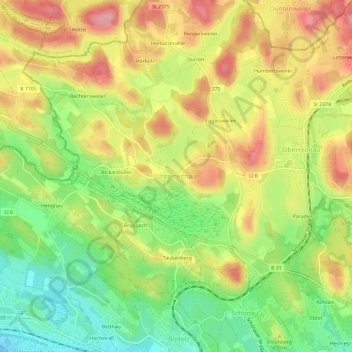
Nome: Mapa topográfico Unterreitnau, altitude, relevo.
Altitude média: 461 m
Altitude mínima: 398 m
Altitude máxima: 524 m
Outros mapas topográficos
Clique em um mapa para visualizar sua topografia, sua altitude e seu relevo.
Rickatshofen
Deutschland > Bayern > Landkreis Lindau > Lindau (Bodensee) > Unterreitnau
Rickatshofen, Unterreitnau, Lindau (Bodensee), Landkreis Lindau, Bayern, 88142, Deutschland
Altitude média: 458 m
Bechtersweiler
Deutschland > Bayern > Landkreis Lindau > Lindau (Bodensee) > Unterreitnau > Bechtersweiler
Bechtersweiler, Unterreitnau, Lindau (Bodensee), Landkreis Lindau, Bayern, 88142, Deutschland
Altitude média: 471 m