
Mapa topográfico Changzhi
Mapa interativo
Clique no mapa para exibir a altitude.
Sobre este mapa
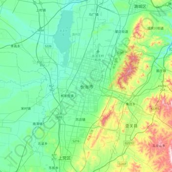
Nome: Mapa topográfico Changzhi, altitude, relevo.
Altitude média: 986 m
Altitude mínima: 870 m
Altitude máxima: 1.396 m
Changzhi is located in southeastern Shanxi province, along the southern section of the Taihang Mountains. The majority of the city's area is mountainous, and much of the remaining geography is hilly in nature. The average elevation in the city is approximately 1,000 metres (3,300 ft) above sea level, with prominent peaks including Liyu Mountain (Chinese: 历峪山; pinyin: Lìyù Shān) and Shigao Mountain (Chinese: 石膏山; pinyin: Shígāo Shān), reaching 2,012 metres (6,601 ft) and 2,541 metres (8,337 ft) above sea level, respectively.