
Faça uma doação
Mapa topográfico Blairsville
Clique no mapa para exibir a altitude.
Faça uma doação
Sobre este mapa
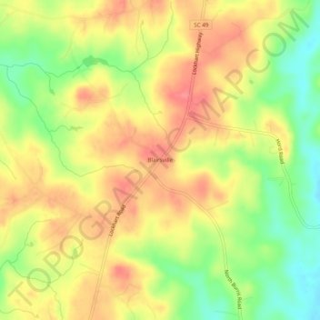
Nome: Mapa topográfico Blairsville, altitude, relevo.
Altitude média: 176 m
Altitude mínima: 133 m
Altitude máxima: 209 m
Faça uma doação
Outros mapas topográficos
Clique em um mapa para visualizar sua topografia, sua altitude e seu relevo.
Rock Hill
United States > South Carolina > York County
Rock Hill is located along the Catawba River in the north-central section of the Piedmont of South Carolina, south of the city of Charlotte in North Carolina. The city sits at an elevation of around 676 feet (206 m) above sea level. It is located approximately 150 miles (240 km) from the Atlantic Ocean and 75…
Altitude média: 184 m
Faça uma doação
Lake Wylie
United States > South Carolina > York County
Lake Wylie is located on a peninsula along the shore of Lake Wylie in the Piedmont of both North and South Carolina, at 35°6′22″N 81°3′25″W / 35.10611°N 81.05694°W / 35.10611; -81.05694 (35.105973, -81.056978). According to the United States Census Bureau, the CDP has a total area of 4.7…
Altitude média: 188 m
Kings Mountain State Park
United States > South Carolina > York County > Blacksburg
Altitude média: 240 m
Faça uma doação
Rock Hill
United States > South Carolina > York County
Rock Hill is located along the Catawba River in the north-central section of the Piedmont of South Carolina, south of the city of Charlotte in North Carolina. The city sits at an elevation of around 676 feet (206 m) above sea level. It is located approximately 150 miles (240 km) from the Atlantic Ocean and 75…
Altitude média: 184 m
Faça uma doação
Lake Wylie
United States > South Carolina > York County
Lake Wylie is located on a peninsula along the shore of Lake Wylie in the Piedmont of both North and South Carolina, at 35°6′22″N 81°3′25″W / 35.10611°N 81.05694°W / 35.10611; -81.05694 (35.105973, -81.056978). According to the United States Census Bureau, the CDP has a total area of 4.7…
Altitude média: 188 m