
Obrigado por apoiar este site ❤️
Faça uma doação
Faça uma doação
Mapa topográfico Elizabethton
Clique no mapa para exibir a altitude.
Obrigado por apoiar este site ❤️
Faça uma doação
Faça uma doação
Elizabethton
The elevation at Elizabethton Municipal Airport is 1,593 feet (486 m) ASL (the highest point of elevation in Carter County is at Roan Mountain with an elevation of 6,285 feet (1,916 m) ASL), and the airport is located on the eastern side of the city along State Highway 91 Stoney Creek Exit. Elizabethton is also connected to larger commercial, shuttle, and cargo flights out of Tri-Cities Regional Airport northwest of Johnson City.
Obrigado por apoiar este site ❤️
Faça uma doação
Faça uma doação
Sobre este mapa
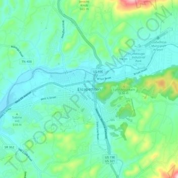
Nome: Mapa topográfico Elizabethton, altitude, relevo.
Local: Elizabethton, Carter County, Tennessee, 37643, United States (36.30872 -82.25069 36.38872 -82.17069)
Altitude média: 527 m
Altitude mínima: 444 m
Altitude máxima: 849 m
Obrigado por apoiar este site ❤️
Faça uma doação
Faça uma doação