
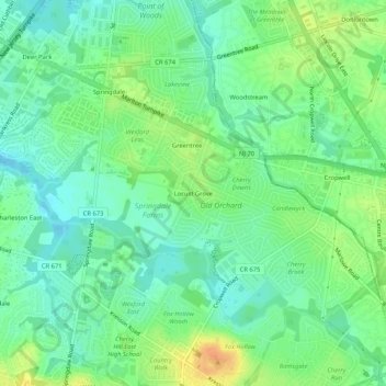
Mapa topográfico Locust Grove
Mapa interativo
Clique no mapa para exibir a altitude.
Sobre este mapa
Nome: Mapa topográfico Locust Grove, altitude, relevo.
Altitude média: 25 m
Altitude mínima: 11 m
Altitude máxima: 47 m
Outros mapas topográficos
Clique em um mapa para visualizar sua topografia, sua altitude e seu relevo.
Cherry Hill Mall
United States > New Jersey > Camden County > Cherry Hill Township
Cherry Hill Mall, Cherry Hill Township, Camden County, New Jersey, 08002, United States
Altitude média: 16 m
Willowdale
United States > New Jersey > Camden County > Cherry Hill Township
Willowdale, Cherry Hill Township, Camden County, New Jersey, 08003, United States
Altitude média: 25 m
Deer Park
United States > New Jersey > Camden County > Cherry Hill Township
Deer Park, Cherry Hill Township, Camden County, New Jersey, 08003, United States
Altitude média: 20 m
Cooper River Lake
United States > New Jersey > Camden County > Cherry Hill Township > Stoys Landing
Cooper River Lake, Stoys Landing, Cherry Hill Township, Camden County, New Jersey, United States
Altitude média: 10 m
Stoys Landing
United States > New Jersey > Camden County > Cherry Hill Township
Stoys Landing, Cherry Hill Township, Camden County, New Jersey, 08002, United States
Altitude média: 14 m
Colwick
United States > New Jersey > Camden County > Cherry Hill Township
Colwick, Cherry Hill Township, Camden County, New Jersey, 08002, United States
Altitude média: 15 m