
Faça uma doação
Mapa topográfico Isla Santa Cruz
Clique no mapa para exibir a altitude.
Faça uma doação
Isla Santa Cruz
Santa Cruz Island (Spanish pronunciation: [ˈsanta ˈkɾus]) is one of the Galápagos Islands with an area of 986 km2 (381 sq mi) and a maximum altitude of 864 metres (2,835 ft). Situated in the center of the archipelago, Santa Cruz is the second largest island after Isabela. Its capital is Puerto Ayora, the most populated urban centre in the islands. On Santa Cruz, there are some small villages, whose inhabitants work in agriculture and cattle raising.
Faça uma doação
Sobre este mapa
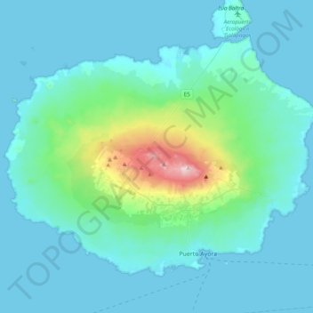
Nome: Mapa topográfico Isla Santa Cruz, altitude, relevo.
Local: Isla Santa Cruz, Cantón Santa Cruz, Galápagos, Ecuador (-0.77529 -90.55007 -0.48226 -90.16878)
Altitude média: 95 m
Altitude mínima: 0 m
Altitude máxima: 858 m
Faça uma doação
Outros mapas topográficos
Clique em um mapa para visualizar sua topografia, sua altitude e seu relevo.
Isla Pinzón
Ecuador > Galápagos > Cantón Santa Cruz
Pinzón or Pinzon Island (Spanish: Isla Pinzón) is an island in Ecuador's Galápagos Archipelago. It has no permanent population, an area of 18 square kilometers (6.9 sq mi), and a maximum elevation of 458 meters (1,503 ft). Home to giant Galápagos tortoises of the subspecies Chelonoidis duncanensis and…
Altitude média: 124 m
Faça uma doação
Isla Plaza Sur
Ecuador > Galápagos > Cantón Santa Cruz
South Plaza (Spanish: Isla Plaza Sur) is a small island off the east coast of Santa Cruz in the Galápagos Islands. It has an area of 0.13 km2 and a maximum altitude of 23 metres.
Altitude média: 5 m
Faça uma doação