
Faça uma doação
Mapa topográfico Lake Kaweah
Clique no mapa para exibir a altitude.
Faça uma doação
Sobre este mapa
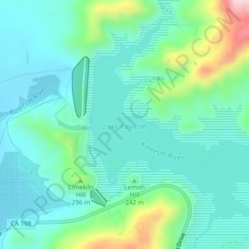
Nome: Mapa topográfico Lake Kaweah, altitude, relevo.
Local: Lake Kaweah, Tulare County, California, United States (36.40160 -119.00292 36.42370 -118.97089)
Altitude média: 228 m
Altitude mínima: 152 m
Altitude máxima: 497 m
Faça uma doação
Outros mapas topográficos
Clique em um mapa para visualizar sua topografia, sua altitude e seu relevo.
General Sherman Tree
United States > California > Tulare County
General Sherman is a giant sequoia (Sequoiadendron giganteum) tree located at an elevation of 2,109 m (6,919 ft) above sea level in the Giant Forest of Sequoia National Park in Tulare County, in the U.S. state of California. By volume, it is the largest known living single-stem tree on Earth.
Altitude média: 2.114 m
Faça uma doação
Faça uma doação
Faça uma doação
Porterville
United States > California > Tulare County > Porterville
Porterville, lying along the foothills of the Sierras at an elevation of 455 feet (139 m), is located on State Highway 65, 165 miles (266 km) north of Los Angeles, and 171 miles (275 km) east of the Pacific Coast. The city has a strategic central location to major markets and a ready access to major…
Altitude média: 222 m
Faça uma doação