
Faça uma doação
Mapa topográfico Kandhkot
Clique no mapa para exibir a altitude.
Faça uma doação
Sobre este mapa
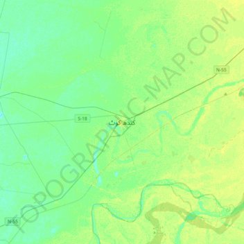
Nome: Mapa topográfico Kandhkot, altitude, relevo.
Local: Kandhkot, Sindh, Pakistan (28.08490 69.02142 28.40490 69.34142)
Altitude média: 69 m
Altitude mínima: 62 m
Altitude máxima: 78 m
Faça uma doação
Outros mapas topográficos
Clique em um mapa para visualizar sua topografia, sua altitude e seu relevo.
Karachi Division
Karachi lies very close to a major fault line, where the Indian tectonic plate meets the Arabian tectonic plate. However, Karachi lies near the western edge of the Indian Plate, on the Indo Gangetic Plain. Within the city of Karachi are two small ranges: the Khasa Hills and Mulri Hills, which lie in the…
Altitude média: 89 m
Faça uma doação
Faça uma doação
Karachi Division
Karachi lies very close to a major fault line, where the Indian tectonic plate meets the Arabian tectonic plate. However, Karachi lies near the western edge of the Indian Plate, on the Indo Gangetic Plain. Within the city of Karachi are two small ranges: the Khasa Hills and Mulri Hills, which lie in the…
Altitude média: 89 m
Karachi Division
Karachi lies very close to a major fault line, where the Indian tectonic plate meets the Arabian tectonic plate. Within the city of Karachi are two small ranges: the Khasa Hills and Mulri Hills, which lie in the northwest and act as a barrier between North Nazimabad and Orangi. Karachi's hills are barren and…
Altitude média: 89 m
Faça uma doação
Karachi Division
Karachi lies very close to a major fault line, where the Indian tectonic plate meets the Arabian tectonic plate. However, Karachi lies near the western edge of the Indian Plate, on the Indo Gangetic Plain. Within the city of Karachi are two small ranges: the Khasa Hills and Mulri Hills, which lie in the…
Altitude média: 89 m
Faça uma doação
Faça uma doação
Faça uma doação
Faça uma doação
Faça uma doação
Faça uma doação
Faça uma doação
Faça uma doação
Faça uma doação
Faça uma doação