
Mapa topográfico Ferny Creek
Mapa interativo
Clique no mapa para exibir a altitude.
Ferny Creek
Ferny Creek's climate is cool and wet, with temperature extremes rare due to the proximity of Port Phillip Bay and Bass Strait. Rainfall is fairly uniform through the year, tending to peak between April and October with lower rainfall during the months of January and February. The mean annual rainfall is between 1100 and 1500 mm, increasing with elevation and from west to east. The elevation means that temperatures are typically 3 to 5 °C cooler than the lower suburbs of Melbourne, to the west of Ferny Creek.
Sobre este mapa
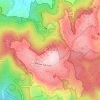
Nome: Mapa topográfico Ferny Creek, altitude, relevo.
Altitude média: 423 m
Altitude mínima: 180 m
Altitude máxima: 570 m
Outros mapas topográficos
Clique em um mapa para visualizar sua topografia, sua altitude e seu relevo.
Mount Dandenong
Australia > Victoria > Melbourne
Mount Dandenong has a cool oceanic climate (Cfb), with cool to mild summers and cold, damp winters. Daytime temperatures are usually 4−6 °C cooler than downtown Melbourne due to its elevation and distance from the urban heat island effect of Melbourne. It is significantly cloudier than Melbourne,…
Altitude média: 395 m
Yarra Valley
Australia > Victoria > Melbourne
The Yarra Valley is the region surrounding the Yarra River in Victoria, Australia. The river originates approximately 240 km (150 mi) east of the Melbourne central business district and flows towards it and out into Port Phillip Bay. The name Yarra Valley is used in reference to the upper regions surrounding…
Altitude média: 305 m
Dandenong Ranges
Australia > Victoria > Melbourne
The topography consists of a series of ridges dissected by deeply cut streams. Sheltered gullies in the south of the range are home to temperate rain forest, fern gullies and Mountain Ash forest Eucalyptus regnans, whereas the drier ridges and exposed northern slopes are covered by dry sclerophyll forest of…
Altitude média: 456 m
Australian Garden - Royal Botanic Gardens Cranbourne
Australia > Victoria > Melbourne
Altitude média: 70 m
Gilbertsons Grassland Nature Conservation Reserve
Australia > Victoria > Melbourne
Altitude média: 36 m
Dandenong Ranges
Australia > Victoria > Melbourne
The topography consists of a series of ridges dissected by deeply cut streams. Sheltered gullies in the south of the range are home to temperate rain forest, fern gullies and Mountain Ash forest Eucalyptus regnans, whereas the drier ridges and exposed northern slopes are covered by dry sclerophyll forest of…
Altitude média: 456 m
Narre Warren North Retarding Basin (Melbourne Water)
Australia > Victoria > Melbourne
Altitude média: 76 m