
Mapa topográfico Mézières-en-Brenne
Mapa interativo
Clique no mapa para exibir a altitude.
Sobre este mapa
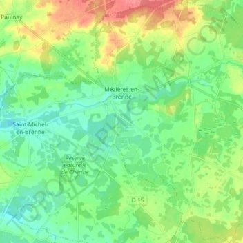
Nome: Mapa topográfico Mézières-en-Brenne, altitude, relevo.
Altitude média: 100 m
Altitude mínima: 78 m
Altitude máxima: 144 m
Outros mapas topográficos
Clique em um mapa para visualizar sua topografia, sua altitude e seu relevo.
Fontguenand
Frankrijk > Centre-Val de Loire > Indre
Fontguenand, Châteauroux, Indre, Centre-Val de Loire, Metropolitaans Frankrijk, 36600, Frankrijk
Altitude média: 121 m
Gournay
Frankrijk > Centre-Val de Loire > Indre
Gournay, La Châtre, Indre, Centre-Val de Loire, Metropolitaans Frankrijk, 36230, Frankrijk
Altitude média: 206 m
Néret
Frankrijk > Centre-Val de Loire > Indre
Néret, La Châtre, Indre, Centre-Val de Loire, Metropolitaans Frankrijk, 36400, Frankrijk
Altitude média: 243 m
36230
Frankrijk > Centre-Val de Loire > Indre > Neuvy-Saint-Sépulchre
36230, Neuvy-Saint-Sépulchre, La Châtre, Indre, Centre-Val de Loire, Metropolitaans Frankrijk, Frankrijk
Altitude média: 203 m
Éguzon
Frankrijk > Centre-Val de Loire > Indre > Éguzon-Chantôme
Éguzon, Éguzon-Chantôme, Châteauroux, Indre, Centre-Val de Loire, Metropolitaans Frankrijk, 36270, Frankrijk
Altitude média: 255 m
Mouhet
Frankrijk > Centre-Val de Loire > Indre
Mouhet, Le Blanc, Indre, Centre-Val de Loire, Metropolitaans Frankrijk, 36170, Frankrijk
Altitude média: 292 m
Thenay
Frankrijk > Centre-Val de Loire > Indre
Thenay, Le Blanc, Indre, Centre-Val de Loire, Metropolitaans Frankrijk, 36800, Frankrijk
Altitude média: 152 m
La Fouchette
Frankrijk > Centre-Val de Loire > Indre > Levroux
La Fouchette, Saint-Pierre-de-Lamps, Levroux, Châteauroux, Indre, Centre-Val de Loire, Metropolitaans Frankrijk, 36110, Frankrijk
Altitude média: 152 m
Saint-Genou
Frankrijk > Centre-Val de Loire > Indre
Saint-Genou, Châteauroux, Indre, Centre-Val de Loire, Metropolitaans Frankrijk, 36500, Frankrijk
Altitude média: 118 m
Nohant-Vic
Frankrijk > Centre-Val de Loire > Indre > Nohant-Vic
Nohant-Vic, La Châtre, Indre, Centre-Val de Loire, Metropolitaans Frankrijk, 36400, Frankrijk
Altitude média: 217 m
Villedieu-sur-Indre
Frankrijk > Centre-Val de Loire > Indre
Villedieu-sur-Indre, Châteauroux, Indre, Centre-Val de Loire, Metropolitaans Frankrijk, 36320, Frankrijk
Altitude média: 142 m