
Mapa topográfico Ambaji
Mapa interativo
Clique no mapa para exibir a altitude.
Sobre este mapa
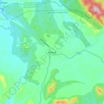
Nome: Mapa topográfico Ambaji, altitude, relevo.
Altitude média: 453 m
Altitude mínima: 330 m
Altitude máxima: 916 m
Ambaji is a town within taluka district Banaskantha, North Gujarat, India. It is located at 24°20′N 72°51′E / 24.33°N 72.85°E / 24.33; 72.85. It is at an altitude of 480 metres (1,570 ft). It is surrounded by the Araveli Hill range. Ambaji is within the Aravali Range'line of peaks', is a range of mountains in western India running approximately 800 km in a northeastern direction across Indian states of Gujarat, Rajasthan, Haryana and Delhi. It is also called Mewat hills locally. Ambaji town also in between the borders of North Gujarat and Abu Road of Rajasthan.
Outros mapas topográficos
Clique em um mapa para visualizar sua topografia, sua altitude e seu relevo.
Danta
India > Gujarat > Danta Taluka > Danta
Danta, Danta Taluka, Banas Kantha District, Gujarat, 385120, India
Altitude média: 326 m