
Mapa topográfico Monroe County
Mapa interativo
Clique no mapa para exibir a altitude.
Sobre este mapa
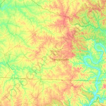
Nome: Mapa topográfico Monroe County, altitude, relevo.
Local: Monroe County, Kentucky, United States of America (36.61499 -85.97704 36.84161 -85.43633)
Altitude média: 250 m
Altitude mínima: 156 m
Altitude máxima: 414 m
Outros mapas topográficos
Clique em um mapa para visualizar sua topografia, sua altitude e seu relevo.
High Plains
United States of America > Kentucky > High Plains
High Plains, Breckinridge County, Kentucky, 40115, United States of America
Altitude média: 228 m
Covington
United States of America > Kentucky > Covington
Covington, Kenton County, Kentucky, United States of America
Altitude média: 215 m
Pineville
United States of America > Kentucky > Pineville
Pineville, Bell County, Kentucky, United States of America
Altitude média: 426 m
Ready
United States of America > Kentucky > Ready
Ready, Grayson County, Kentucky, United States of America
Altitude média: 206 m
Cumberland County
United States of America > Kentucky
Cumberland County, Kentucky, United States of America
Altitude média: 237 m
Pomp
United States of America > Kentucky > Pomp
Pomp, Morgan County, Kentucky, 41472, United States of America
Altitude média: 282 m
Lawrenceburg
United States of America > Kentucky > Lawrenceburg > Lawrenceburg
Lawrenceburg, Anderson County, Kentucky, 40342, United States of America
Altitude média: 244 m
Millard
United States of America > Kentucky > Millard
Nelse, Millard, Pike County, Kentucky, 41562, United States of America
Altitude média: 315 m
Metcalfe County
United States of America > Kentucky
Metcalfe County, Kentucky, United States of America
Altitude média: 251 m