
Mapa topográfico Bamberton Provincial Park
Mapa interativo
Clique no mapa para exibir a altitude.
Sobre este mapa
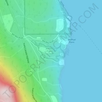
Nome: Mapa topográfico Bamberton Provincial Park, altitude, relevo.
Altitude média: 97 m
Altitude mínima: 0 m
Altitude máxima: 554 m
Outros mapas topográficos
Clique em um mapa para visualizar sua topografia, sua altitude e seu relevo.
Mill Bay
Canada > British Columbia > Cowichan Valley Regional District > Area A (Mill Bay / Malahat)
Mill Bay, Area A (Mill Bay / Malahat), Cowichan Valley Regional District, British Columbia, V0R 2P1, Canada
Altitude média: 61 m
H500
Canada > British Columbia > Cowichan Valley Regional District > Area A (Mill Bay / Malahat)
H500, Area A (Mill Bay / Malahat), Cowichan Valley Regional District, British Columbia, V0R 2P4, Canada
Altitude média: 341 m