
Mapa topográfico Stoke
Clique no mapa para exibir a altitude.
Sobre este mapa
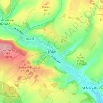
Nome: Mapa topográfico Stoke, altitude, relevo.
Altitude média: 128 m
Altitude mínima: 74 m
Altitude máxima: 200 m
Outros mapas topográficos
Clique em um mapa para visualizar sua topografia, sua altitude e seu relevo.
Winterhill Plantation
United Kingdom > England > Hampshire > Basingstoke and Deane > Whitchurch > Wells-In-The-Field
Altitude média: 100 m
Basingstoke
United Kingdom > England > Hampshire > Basingstoke and Deane
Situated in a valley through the Hampshire Downs at an average elevation of 88 metres (289 ft) Basingstoke is a major interchange between Reading, Newbury, Andover, Winchester, and Alton, and lies on the natural trade route between the southwest of England and London. The area had been something of an…
Altitude média: 109 m
Morgaston Wood
United Kingdom > England > Hampshire > Basingstoke and Deane > Sherborne St John
Altitude média: 76 m
Mortimer West End
United Kingdom > England > Hampshire > Basingstoke and Deane > Mortimer West End
Altitude média: 90 m
Wootton St. Lawrence
United Kingdom > England > Hampshire > Basingstoke and Deane
Altitude média: 115 m
Sherborne St. John
United Kingdom > England > Hampshire > Basingstoke and Deane > Sherborne St John
Altitude média: 79 m
Bramley Corner
United Kingdom > England > Hampshire > Basingstoke and Deane > Bramley
Altitude média: 69 m
Monk Sherborne
United Kingdom > England > Hampshire > Basingstoke and Deane > Monk Sherborne
Altitude média: 107 m
Kingsclere
United Kingdom > England > Hampshire > Basingstoke and Deane > Kingsclere
Altitude média: 139 m
Chineham
United Kingdom > England > Hampshire > Basingstoke and Deane > Basingstoke
Altitude média: 78 m
River Lyde
United Kingdom > England > Hampshire > Basingstoke and Deane > Up Nately
Altitude média: 78 m
Baughurst
United Kingdom > England > Hampshire > Basingstoke and Deane > Wolverton Townsend
Altitude média: 106 m
St. Mary Bourne
United Kingdom > England > Hampshire > Basingstoke and Deane > Stoke
Altitude média: 125 m
East Woodhay
United Kingdom > England > Hampshire > Basingstoke and Deane > East End
Altitude média: 171 m
Wootton St. Lawrence
United Kingdom > England > Hampshire > Basingstoke and Deane
Altitude média: 115 m
Chineham
United Kingdom > England > Hampshire > Basingstoke and Deane > Basingstoke
Altitude média: 78 m
Highclere
United Kingdom > England > Hampshire > Basingstoke and Deane > Highclere
Altitude média: 154 m
Highclere
United Kingdom > England > Hampshire > Basingstoke and Deane > Highclere
Altitude média: 154 m