
Mapa topográfico Cuyahoga River
Mapa interativo
Clique no mapa para exibir a altitude.
Sobre este mapa
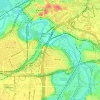
Nome: Mapa topográfico Cuyahoga River, altitude, relevo.
Altitude média: 196 m
Altitude mínima: 165 m
Altitude máxima: 230 m
The upper Cuyahoga River, starting at 1,093 feet (333 m) over 84 miles (135 km) from its mouth, drops in elevation fairly steeply, creating falls and rapids in some places; the lower Cuyahoga River only drops several feet along the last several miles of the lower river to 571 feet (174 m) at the mouth on Lake Erie, resulting in relatively slow-moving waters that can take a while to drain compared to the upper Cuyahoga.
Outros mapas topográficos
Clique em um mapa para visualizar sua topografia, sua altitude e seu relevo.
Cleveland
United States > Ohio > Cuyahoga County > Cleveland
Cleveland, Cuyahoga County, Ohio, 44113, United States
Altitude média: 221 m