
Faça uma doação
Mapa topográfico Nine Mile Lake
Clique no mapa para exibir a altitude.
Faça uma doação
Sobre este mapa
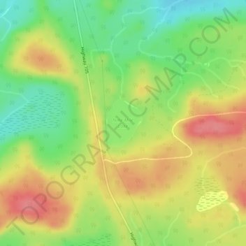
Nome: Mapa topográfico Nine Mile Lake, altitude, relevo.
Altitude média: 413 m
Altitude mínima: 374 m
Altitude máxima: 449 m
Faça uma doação
Outros mapas topográficos
Clique em um mapa para visualizar sua topografia, sua altitude e seu relevo.
Faça uma doação
Faça uma doação
Hudson Bay Lowlands
Canada > Ontario > Kenora District > Unorganized Kenora District
Altitude média: 17 m
Faça uma doação
Faça uma doação
Confederation Lake
Canada > Ontario > Kenora District > Unorganized Kenora District
Altitude média: 414 m
Faça uma doação
Two Island Lake
Canada > Ontario > Kenora District > Unorganized Kenora District
Altitude média: 361 m
lac Seul
Canada > Ontario > Kenora District > Unorganized Kenora District
Lac Seul is a large, crescent shaped reservoir in Kenora District, northwestern Ontario, Canada. It is approximately 241 km (150 mi) long. It has a maximum (regulated) depth of 47.2 m, with a surface elevation of 357 m above sea level. Its level is raised in the summer and then drawn down in the winter months…
Altitude média: 374 m
Faça uma doação
Faça uma doação
Blackstone Lake
Canada > Ontario > Kenora District > Unorganized Kenora District
Altitude média: 382 m
Faça uma doação
Faça uma doação
Faça uma doação
Faça uma doação
Faça uma doação
Faça uma doação
Faça uma doação