
Mapa topográfico Pukanec
Mapa interativo
Clique no mapa para exibir a altitude.
Sobre este mapa
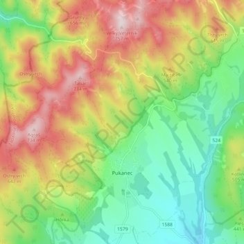
Nome: Mapa topográfico Pukanec, altitude, relevo.
Altitude média: 462 m
Altitude mínima: 259 m
Altitude máxima: 743 m
The village lies at an altitude of 354 metres and covers an area of 26.196 km2. It has a population of 2067 people. It is located near the Štiavnica Mountains, in the Sikenica river valley. It is located around 18 km northeast of Levice.
Outros mapas topográficos
Clique em um mapa para visualizar sua topografia, sua altitude e seu relevo.
Nový Tekov
Slovakia > Region of Nitra > District of Levice
Nový Tekov, District of Levice, Region of Nitra, Western Slovakia, 935 33, Slovakia
Altitude média: 176 m
Veľký Ďur
Slovakia > Region of Nitra > District of Levice
Veľký Ďur, District of Levice, Region of Nitra, Western Slovakia, 935 34, Slovakia
Altitude média: 192 m